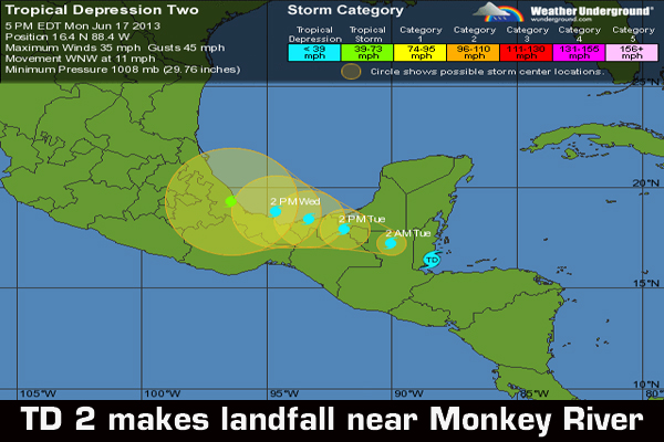
Bringing heavy rains and 35-mile-per hour winds, Tropical Depression Two, which formed from a tropical wave over the northwestern Caribbean Sea near the Nicaragua/Honduras border earlier today, trekked ashore Belize near Monkey River, Stann Creek, mid-afternoon today, rendering portions of southern Belize impassable.
Belize’s National Emergency Management Organization (NEMO) advised that, “Persons living in flood-prone areas across the country are advised to be on the alert for possible flooding in your areas as the system moves across Belize. Motorists are also advised to exercise extreme caution when driving on the highways and secondary roads.”
Concerned about the latest developments, the Ministry of Education called off classes for certain portions of Belize, deemed to be under threat of flooding, to ensure that students would be able to get home safely.
“The primary concern with this system is heavy rainfall which could cause significant flooding over portions of Central America and eastern Mexico,” said forecasters at the US National Hurricane Center in Miami.
They add that the center will move over Belize and northern Guatemala tonight and early Tuesday, and over eastern Mexico later on Tuesday. The depression could emerge into the southern Bay of Campeche by early Wednesday, and become the second named storm of this very active hurricane season.
The National Meteorological Service had said that a small craft warning remains in effect for coastal Belize, which means that small crafts should seek and stay in safe harbor.
TD2 could dump as many as 6 inches of rain on Belize; but forecaster Ronald Gordon of the Belize National Met Service said that there could be more rains than forecast. Already, the Philip Goldson International Airport was recording 2.9 inches of rainfall for the last 24 hours, while Melinda in Stann Creek was reporting 2.7 inches.
Gordon said that most of the rainfall was being seen along the north and northeastern parts of Belize, according to the images available to them on the Doppler Radar.
As early as Monday morning, rains associated with TD2 had already flooded the Boom Creek Road in Toledo with four feet of water. National Emergency Coordinator, Noreen Fairweather, told Amandala that flood levels at that location, which have essentially severed the Boom Creek Community, have been fluctuating and registered 3.5 feet mid-afternoon.
NEMO advised that, “wind gusts to near tropical storm force are occurring over portions of the country and this is likely to continue tonight. Flooding is also highly likely over low-lying areas.”
By Monday evening, the depression had rendered the portion of the Coastal Road leading to the Mullins River community impassable, as the Mullins River rose to 3 feet above the temporary bridge, installed there after Tropical Storm Arthur washed away the original bridge back in 2008. (Five years later, Mullins River has yet to get its replacement bridge.)
As the tropical depression was making landfall, reports of localized flooding increased. NEMO reported that the North Stann Creek River was 3-ft above normal and rising in Middlesex, Pomona and Hope Creek; South Stann Creek River was 3-ft above normal and rising; and the Sittee River was 4-ft above normal and rising.
Meanwhile, Miles 13, 18 and 20 on the Hummingbird Highway were under water, while the Bowman Housing Area in Stann Creek, at Mile 15, was under 6 inches of water.
In Toledo, Blue Creek was 4 inches below the bridge and rising, while the Bladden, Temash & Moho Rivers were said to be above normal and rising.
Forecaster Gordon told Amandala that the rains are expected to continue into Tuesday, gradually dissipating on Wednesday. On Tuesday, similar intense rainfalls with possible thunderstorms are expected until later in the day. Gusty winds are going to persist behind the system, Gordon told us.
Gordon noted that this is the favored area for storms to form during this time of the year. Generally, the Western Caribbean is where they tend to form early and late during the hurricane season.
Up to 20 named storms have been forecast for the 2013 Atlantic Hurricane Season. The first named storm, Andrea, made landfall in northern Florida on June 6.
The remaining names on the list are Barry, Chantal, Dorian, Erin, Fernand, Gabrielle, Humberto, Ingrid, Jerry, Karen, Lorenzo, Melissa, Nestor, Olga, Pablo, Rebekah, Sebastien, Tanya, Van, and Wendy.

