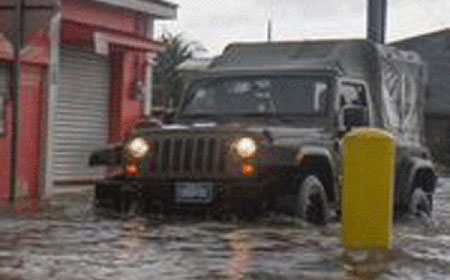
BELIZE CITY, Mon. Oct. 19, 2015–As we go to press, the roar of the thunder confirms the latest advisory issued tonight by the National Emergency Management Organization (NEMO)—that a new tropical disturbance right on our doorsteps will bring more rain and thunderstorms, even as northern Belize, and particular the Old Capital, Belize City, is reeling from what many perceive to be the most devastating flood in recent memory.
The catastrophic flood caused by a tropical depression associated with a broad area of disturbance spanning Mexico and parts of Central America, has been described as the largest weather event to affect Belize City since Hurricane Hattie, which hit Belize in this same month in 1961.
The Prime Minister of Belize, Hon. Dean Barrow, and NEMO held a press conference on Sunday October 18, to address this high-impact weather event that has affected Belize City and other parts of the country, including the districts of Orange Walk and Corozal. Widespread flooding forced the closure of schools on these three districts in central and northern Belize, including the islands of Caye Caulker and Ambergris Caye. There were also reports of localized but substantial flooding in Hope Creek, Stann Creek.
Despite the extensive flooding in Belize City—with 10 inches of rain falling in the 36 hours preceding Sunday’s press conference and another 6-8 inches forecast for the hours ahead—no state of emergency was declared.
The Prime Minister described the massive flood that inundated Belize City and other parts of country on Sunday as a “disaster”.
He said it was a crisis that has precipitated an emergency – small “e,” and added, “While we can’t control the weather—while we can’t control what has happened, we certainly can control our response to the disaster and basically my principal duty here today is to mention that we will do everything required to assist those who have been affected, whatever their needs.”
Also seated at the head table were Godwin Hulse, Minister responsible for NEMO; Michael Finnegan, Minister responsible for Housing; Anthony Martinez, Minister responsible for Human Development; Dennis Gonguez, Chief Meteorologist; and Colonel Defoe, Logistics Officer at NEMO.
No mass evacuations had been ordered in Belize City either, as NEMO personnel are working on case-by-case situations when it comes to evacuating residents whose homes had been flooded. Getting in and out of the city has been problematic as streets, roads, and highways are flooded.
The City Emergency Management Organization (CEMO) was activated during the night on Saturday and assisted some 50 persons from the Conch Shell Bay area who had to be evacuated to the University of Belize’s building at ITVET, which is a designated shelter. At the time of Sunday’s press conference, an official said that 100 people were in shelters.
Although NEMO had said that there are no reports of flooding in other parts of the country at the time, we later learned that indeed, other parts of northern Belize had been seriously impacted.
There were media reports yesterday from Quintana Roo, Mexico, of extensive flooding in Chetumal and subsequent images of damaged infrastructure there.
The Commercial Free Zone’s office in Corozal was closed today, and it was confirmed that the downpour had also drenched the Zone, frequented by Mexican shoppers.
The bridge that connects Belize and Mexico was also under substantial water, making it difficult for vehicles to navigate.
In the coming days, rain will continue according to the forecast and more flooding is anticipated, as flood waters head west.
Residents along rivers, creeks, waterways and low-lying areas whose homes are likely to flood are cautioned to move to a higher ground with family or to a community shelter.
Farmers are advised to start making the necessary preparations for their livestock and crops.
Drivers are asked to slow down and to put on their hazard lights when driving through rain.
In the surrounding countries, heavy rain has been affecting parts of Honduras since 17 October 2015, triggering floods, landslides and overflowing rivers. Local media report that at least 7 people have died in floods in the Comayagua department. As many as 2,000 people have been left homeless in Siguatepeque and the local authorities there have declared a state of emergency.
In Guatemala, the weather has been devastating and the government is still recovering from one of the country’s deadliest natural disasters, when heavy rain resulted in a landslide in the community of El Cambray II, Santa Catarina Pinula municipality on October 2, which left hundreds dead and over 300 missing.
So far, no deaths have been reported in Belize. However, at least one child was reportedly injured when the family’s home fell in Belize City.
We have yet to receive a report on the extent of the impacts, but NEMO representatives have initiated that assessment, the results of which are expected in the days ahead, even as the toll may continue to rise.
“People living along the Macal and Mopan rivers must remain vigilant. The river is now rising and reports are that the Mopan River at La Polvora in Peten, Guatemala is at high flood state. This was reported by the Cayo District Emergency Coordinator, who is visiting and warning the communities along the Mopan River. As the water heads down-stream it will cause severe flooding in Western and Central Belize. The Communities of Arenal, Benque Viejo, Succotz, Calla Creek, Bullet Tree Falls and Santa Familiar must pay particular attention to this notice,” NEMO’s latest advisory says.
It warns that “…additional rains associated with the new area of low pressure is of concern and all must continue to pay close attention to NEMO advisories.”

