Photo: Clearing along survey lines in disputed area claimed by Laguna and Yemeri Grove
TOLEDO DISTRICT, Belize, Tues. Oct. 31, 2023
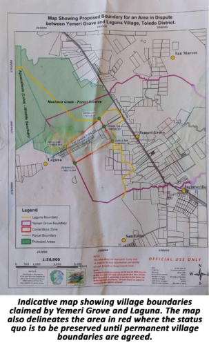
On the heels of a press conference in Belize City last Thursday, October 26, featuring leaders of non-Maya Toledo villages of Yemeri Grove, Jacintoville, Mafredi and Barranco, the Belize City press was taken on a site visit to a portion of the land where primarily Creole village Yemeri and Maya village Laguna have competing ownership claims. The purpose of the press conference was to report that an interim boundary agreement brokered by the two parties in the presence of government officials on October 13 had come apart. Based on the parties’ agreement, the Ministry of Natural Resources’ Land Information Center (LIC) had put together an indicative map to show the respective boundaries as outlined by each village, and also a contentious area marked out in red lines where it was agreed there would be a halt of any activity until a permanent boundary is established. Because the boundaries remain to be worked out, the indicative map shows the overlap in areas claimed by both villages. According to Yemeri, the overlap spans some 2,000 acres. They allege that Laguna is claiming land all the way to the Southern Highway smack in the middle of their village.
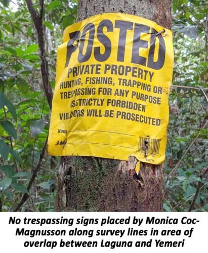
Tuesday’s media tour was led by former Yemeri village councillor Arden Edwards and Village Chairman Herald Usher. The fifteen-minute hike starting at the Southern Highway in Yemeri Grove ended precisely at the boundary of the contentious area in red where the Yemeri leaders say there is a land grab on the part of 2nd Alcalde of Laguna, Monica Coc-Magnusson and her husband. They pointed to land clearings right along survey lines with trees bearing signs that read “POSTED. Private Property. Hunting, fishing, trapping or trespassing for any purpose strictly forbidden.” The gentlemen noted that the tracts of land are in 20-acre blocks, and they pointed to at least two such plots which they say Coc’s husband is claiming behind the Coc’s family yard. Edwards explained, “These surveys here are from the 1930’s. So, what he does, he finds all the Government survey that is there and he just marks from end to end and says this is his.” Asked how they established as much, he said that during a walk-through with officials from the Lands Department and representatives of both villages, Coc’s husband himself claimed ownership of those lands along with his wife. Usher says that on multiple occasions, they have seen Coc’s husband walking the cleared survey lines with dogs and a firearm which has incited fear in some Yemeri residents to the point that they are afraid of going into the area to hunt as they would before.
Chairman Usher expressed anguish and frustration at seeing a claim being made to lands he says they have always considered theirs. He affirmed, “My navel string is planted here. This is all I know. This is where I grow up, and all my life I love to hunt. Hunting is what I do. Once I’m not working, I’m in the bush hunting. So, by actually taking away our land from us, it’s like, you know, everybody is saying ‘the Mayans they need their land because they want to have their lands so they can hunt, they can fish, but we’re Belizean, we’re people, we’re human, and we have the same need. We don’t know about living in towns or the city. We know about living in the village. We know about farming, about hunting, and we know about fishing.” He says if they take away their lands, nothing will remain for their children. Edwards also pointed out that the disputed areas were being left to subdivide for their children, but now that they would like to distribute them, they can’t touch the lands due to the moratorium imposed under the April 2015 Caribbean Court of Justice Consent Order for the Maya Land Rights case.
While on the ground on Tuesday, the media sought out Monica Coc-Magnusson for comment. The Yemeri leaders had made the claim that the land clearly can’t be for the Mayas, given that they don’t use survey pegs in their communal land system. Coc-Magnusson explained that she and her family actually have a lease to the land because at the time that the Malaysians came and obtained concessions for timber extraction, “the Government was saying majority of these lands were terra nullius which means nobody is using them, nobody owns them. So, what had happened was people were trying to get title to their land to secure land tenure – I being one of those at the time. So, I do have an old, old lease on this land, which is an acknowledgement from the government that these are also Laguna lands. And it’s decades long. It’s not a recent lease. That area has been formally surveyed and you saw survey pegs. Those are formal survey pegs.” She reported that they have always been clearing along the survey lines.
Speaking about how much land someone can get under communal land tenure, Coc-Magnusson said it’s determined by the village and it “depends on your need and whether or not you’re accepted in the village … They will look at what land is available and then they would say, ‘ok, this area is available’ and then you go and use the amount that you need.” She explained that the lands were previously used for milpa and rice farming.
While Coc-Magnusson says Laguna has submitted evidence to prove ownership of their land, the Yemeri leaders said their evidence includes existing landmarks used as natural boundaries. Edwards provided the example of the old San Antonio highway which was used by his grandfather and great grandfather. On the opposite end, claims Edwards, there is the old Topcoe Cohune Estate where hundreds of people worked. He added that landmarks have non-Maya names because it was their Yemeri ancestors who named them, and they say this also denotes ownership. Examples provided were “Black Creek” and “Cut and Chroweh”. He commented, “Da we name it,” and that if it had been the Mayas who got there first, the landmarks would have Maya names. Edwards adds that everyone knows the names and who lived in the different areas.
Another point of contention regarding the interim agreement was the maintenance of the status quo. Yemeri has observed that construction on one house in the contentious area continues even now. Coc-Magnusson said that the status quo being preserved means that any new foundation cannot go up in the area but those already started can be finished. A government official told Amandala that it meant that all activity must stop.