
The hypothesis espoused by Mr. Lindsay Belisle regarding the 1859 Treaty as presented in the Amandala of January 25, 2019 is fundamentally flawed.
As I read the article I immediately recognized the work of the Guatemalans as presented in their White Book regarding the opinions of the Mexican Minister for Foreign Affairs, Ignacio Mariscal, in 1882 prior to signing of the boundary treaty between the United Kingdom and Mexico in 1893, delimiting the Belize/Mexican boundary. However, between 1872 and 1884 when the British severed diplomatic relations with Mexico they made it known then that the Yucatecans had controlled the Icaiches Indians whom the British called (a savage tribe) from going into Belizean territory pillaging and destroying the town of Orange Walk. Minister Mariscal lectured the British telling them that they should stop selling and supplying arms to these Indian raiders.
These are points that should be considered when discussing this Belize/Guatemala dispute.
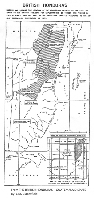
1) No one should confuse the area the King of Spain claimed between 1783 and 1786 with that to which the British claimed, and agreed to by Guatemala in the 1859 treaty.
2) For those who question Article 1 of the 1859 treaty which specifies our boundary “as they existed previous to and on the 1st day of January 1850 and have continued to exist up to the present time.” Perhaps, for the avoidance of doubt this was included to emphasize the signatories that it was previous to the Clayton-Bulwer Treaty of April 19, 1850 when Charles Lennox Wyke convinced Pedro de Aycinena to sign the Treaty which then became irreversible.
3) In April of 1861 the British began to survey the line from Blue Creek @ 17° 59’ 17″ going south towards Garbutt Falls. The job was assigned to Lt. E.C. Abbs but was not continued because his work was interrupted by Indian raids and difficult terrain. I can attest to how difficult that part of Belize was even as late as the early 1950’s when I worked there. While in Southern Belize access was relatively by means of the sea and river, but not so in the northwestern corner, accessible only by trails or by cutting through the jungle.
4) The frontier agreed to between Guatemala and Mexico in 1882 had nothing to do with British Honduras and in fact up to this day the Mexican frontier at 17° 49’ stops short of reaching Belizean territory and there is a reason for this. Therefore, the monument at Aguas Turbias which was erected by Guatemala and Mexico has nothing to do with Belize.
David A.G. Waddell, an eminent scholar of this dispute summed up appropriately the situation today in May of 1960 when he wrote in the “Hispanic American Historical review”. “To the historian it can only be matter for regret that although much time and money continue to be spent in adding to the already voluminous literature of this dispute, so much about its true origins is allowed to remain obscure, while the same incomplete facts and the same inconclusive documents are trotted out again and again”.
As mentioned earlier I had some experience in this northwestern part of our country. I was a member of a geological crew working for the Gulf Oil Corporation led by Dr. Giovanni Flores. Because of the nature of our work, it had to be done in the summer months, the dry season, when most of the rivers and creeks are at their lowest or completely dry exposing the state of sedimentary rocks we were interested in. We were lost for a few days, had food but no water, we had to resort to drinking from vines or suck our socks for moisture, we were surrounded by multiple logging trails – going around in circles. Having been surrounded by mahogany logging camps in my childhood, I hit on the idea of following the direction of barks stripped from huge mahogany logs that were pulled on the ground over rocks leaving marks like arrow heads leading to the Quam Hill mahogany camp.
There are two books which describe our adventures, one the Leo Bradley Library calls “The Adventures of a Petroleum Geologist” by Giovanni Flores and the other, more technical, at the Ministry of Energy, Science and Technology – Geology and Petroleum Department, this is called the GEOLOGY OF NORTHERN BRIRISH HONDURAS – North of the 17th Parallel.