
Photo: (l-r) NEMO’s coordinator, David Mendez; CEO at Ministry of Blue Economy and Disaster Risk Management, Kennedy Carrillo; Chief Meteorologist, Ronald Gordon; and Principal Hydrologist, Tennielle Hendy
NEMO begins update on approaching Hurricane Beryl
by Kristen Ku
BELIZE CITY, Mon. July 1, 2024
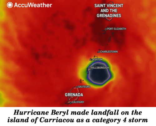
Hurricane Beryl, the first major hurricane of the 2024 Atlantic Hurricane Season, has struck the Windward Islands, causing significant destruction as it advances through the eastern Caribbean region.
What began as a storm on Saturday rapidly intensified by Sunday into a Category 4 hurricane, almost reaching the strength of a Category 5 (157 mph sustained winds and above), with sustained winds of 150 miles per hour. The islands of Grenada, and St. Vincent & the Grenadines have already borne the brunt of Beryl’s fury.
The hurricane’s impact has been severe, with power outages reported across the affected islands, homes destroyed, and schools and businesses forced to shut down. Despite the widespread damage, there have been no reports of fatalities.
It is the first time in two decades that a hurricane of such magnitude has hit the southeastern Caribbean, with the last one being Hurricane Ivan, which caused over a dozen lives to be lost and much destruction in Grenada.
With Belize projected to be one of Hurricane Beryl’s targets by the end of the week, today the Ministry of Blue Economy and Disaster Risk Management, the National Emergency Management Organization (NEMO), the National Meteorological Service, and the Hydrology Unit held a joint press conference at the Fisheries Department in Belize City to inform the public about the latest developments regarding the hurricane and its potential impact on the country.
According to Chief Meteorologist Ronald Gordon, Beryl is currently moving west-northwestward at 20 miles per hour, having passed over the Windward Islands earlier today. The forecast predicts that Beryl will continue on this path, crossing the southeastern Caribbean Sea on Tuesday, approaching the Central Caribbean Sea near Jamaica on Wednesday, and reaching the Northwestern Caribbean Sea by Thursday.
However, Beryl is expected to encounter wind shear in the Central Caribbean, which will likely weaken the storm. Significantly, a high-pressure ridge developing over the Gulf of Mexico is anticipated to change Beryl’s path more westward. The hurricane is projected to pass between Southern Belize and the Northern Yucatan Peninsula, though this forecast is subject to change with several days remaining before potential landfall.
Additionally, the press conference also announced that NEMO will activate its operational committees on Tuesday, July 2. These committees are tasked with developing and implementing plans to prepare for the hurricane’s arrival.
“We will continue to do preparations across the country; we are ensuring that staffs at our warehouses are updated and that we are preparing for the arrival of this sometime on Friday,” shared NEMO’s coordinator, David Mendez.
Residents, especially those in low-lying and flood-prone areas, are urged to begin making preparations before Thursday night, as Beryl’s impacts could be felt by then. “You must have … you must know what to do; you must know where to go; you must have some sort of plan; and you cannot wait until the last minute. We do have a few days more before the arrival of this, and so we do have to start taking those measures: individually, personally within your business and all your organizations,” Mendez informed.
In anticipation of Beryl’s arrival, hurricane shelters are being prepared across the country, with availability based on the storm’s severity. The Belize Defence Force, Public Officers, Coast Guard, and volunteers are on standby to provide additional manpower as needed.
Unfortunately, as seen over the weekend, heavy rains have already caused significant flooding in parts of Belize. This was seen particularly where portions of Corozal were inundated, with some areas experiencing up to 12 inches of water.
According to Principal Hydrologist Tennielle Hendy, this has left the ground extremely saturated, which is a concern especially if Hurricane Beryl brings additional rainfall causing further flooding.
“Right now, the entire north and part of central Belize, the soil is very saturated. So, there’s not a lot of room to play for any water to infiltrate through the soils. They’re at capacity, they’ve taken all that they can take. And so, what happens is that turns into runoff, leads into flooding, and eventually goes to the river. So, we have to be monitoring soil moisture, precipitation levels, tidal levels, and flooding coming from neighboring countries, and it’s a very unique complex,” explained the Principal Hydrologist, Tennielle Hendy.
Beryl’s arrival is breaking records as it’s an early start to the Atlantic hurricane season. On Sunday, it became the earliest Category 4 hurricane on record in the Atlantic Ocean and the first Category 4 hurricane to form in June.
The abnormally warm ocean waters that fueled Beryl’s strengthening are indicative of a highly active and potentially dangerous hurricane season. The current ocean temperatures are similar to those typically observed at the peak of hurricane season in August and September.
To ensure continuous public awareness and safety, NEMO and the National Meteorological Service will provide daily virtual hurricane updates starting Tuesday, July 2, at 7:30 a.m., and continuing through July 5. These updates will offer the latest information on Hurricane Beryl’s path, strength, and potential impacts, allowing residents to stay informed and take necessary precautions.
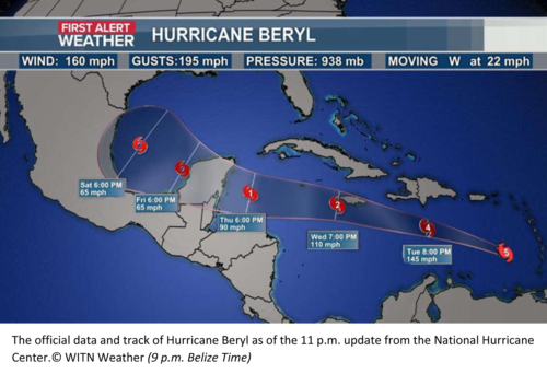
At 9:00 p.m. tonight, NEMO issued its Advisory No. 1 which showed the center of Beryl located at latitude 13.8 degrees North, and longitude 64.9 degrees West. “Beryl was moving to the west-northwest at 22 mph with maximum sustained winds of 160 mph and minimum central pressure of 938 mb.” Beryl is projected “to continue on a general west to west-northwestward track for the next few days…” and should “make landfall either on Belize or north of Belize on the Yucatan Peninsula of Mexico late Thursday night or early Friday morning.” “Some weakening is expected… but it is still expected to make landfall as a significant hurricane.”
As comparison, Hurricane Hattie of October 31, 1961, according to Wikipedia, after moving generally northward, “Hattie then turned westward west of Jamaica and strengthened into a Category 5 hurricane, with maximum sustained winds of 165 mph (270 km/h). It weakened to Category 4 before making landfall south of Belize City on October 31.” The lowest pressure recorded for Hattie was 914 mbar.