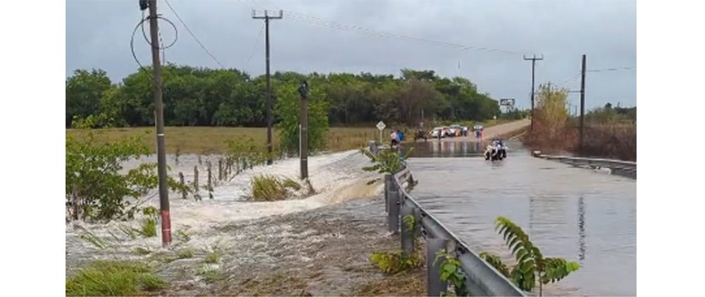
Photo: Flooding of road in Orange Walk District
by Kristen Ku
BELIZE CITY, Thurs. June 20, 2024
Over the weekend, various parts of the country experienced significant rainfall, leading to flooding, damage to infrastructure and homes, and blockage of streets and bridges.
On Sunday, June 16, the National Emergency Management Organization (NEMO) sprang into action to assist families in the August Pine Ridge area, Orange Walk District, who were hit by sudden flash floods. The rains started around 5:30 a.m. and continued for 2-3 hours, causing the nearby creek to overflow.
Approximately eight families suffered varying degrees of damage to their homes, with one family losing everything they owned. Despite the floodwaters covering the bridge near that community by about 2 feet, the water quickly receded, allowing those who had evacuated to return home swiftly. Fortunately, no shelters had to be opened, and there was no significant damage to infrastructure.
“That flooding occurred at one of the bridges within August Pine Ridge Village. It was approximately around Mile 15, I understand, 15 or 15.2, whereby, due to the high intensity of rainfall, that inundated that small bridge that was there,” explained Evondale Moody, Chief Engineer at the Ministry of Infrastructure Development and Housing (MIDH). “In terms of structural failures, there was no damages or anything to the bridge structure or the approaches to that bridge structure, because the water was basically moving at a slow velocity,” he further said.
However, not all areas were spared structural damage. Portions of the newly inaugurated Coastal Highway, farther south—at Mile 17.5 on the northern approach to the Soldier Creek bridge—were damaged following the rains on Sunday in the Stann Creek District.
According to Moody, the damage was caused by water overflow from the culvert due to a blockage of the Soldier Creek by logs from land clearing and debris from recent forest fires upstream.
“We have two culverts there that are three meters wide by 1.5 meters high. And so, because of the blockage of the Creek, that runoff was diverted to the tributaries that are the inlet for those culverts, instead of going into the Creek itself and under the bridge,” Moody explained, noting with some amazement that the road had been significantly raised during its construction to prevent such issues.
With forecasts indicating more showers and thunderstorms as the weekend approaches, clearing of the culverts is crucial to avoid further damage. Yesterday, the National Hurricane Center in Miami announced the formation of the first tropical storm of the season, named Alberto. Moving west at 9 mph, Alberto was positioned 185 miles east of Tampico, Mexico, and 295 miles south-southeast of Brownsville, Texas, with top sustained winds of 40 mph.
Alberto is the first of approximately 25 named storms predicted for this Atlantic Hurricane Season, which runs from June 1 to November 30. According to the Chief Meteorologist, Ronald Gordon, Alberto is not headed directly toward Belize.
“That storm formed in the Gulf of Mexico and is moving away from Belize. It is no direct threat to the country. It is forecast to make landfall over Mexico, into early Thursday morning,” he said.
But despite Alberto not being a direct threat to the country, Gordon has warned residents not to become complacent, as these rains can still cause potentially devastating consequences. Rains are expected to continue up until Sunday, though less severe. The rest of the week is thus expected to be wet, with precipitation peaking on Thursday.
Gordon explained that Belize is expecting significant rainfall and strong thunderstorms due to a broad area of low pressure combined with another low-pressure system moving from the Bahamas to eastern Cuba. This system will create a lot of thunderstorm activity and heavy rains, especially in the central and northern parts of the country.
“The forecast is showing that rains will start later around after midnight into early morning and gradually increase throughout the day tomorrow,” Gordon said on Wednesday. “Some of the models are showing totals of up to four to six inches [of rainfall], with an isolated maximum of 10 inches within a 12 to 24-hour period,” he went on to say.
Due to the expected weather, an excessive-rainfall watch and a strong-thunderstorm watch have been issued. “We are looking at winds of up to 20 to 30 knots tomorrow, especially during the afternoon into evening hours along coastal and offshore areas,” Gordon added. This will result in hazardous sea conditions, and a small craft warning will be issued, advising mariners to stay in a safe harbor.
In light of these developments, this week the Minister of Disaster Risk Management, Hon. Andre Perez, reassured the public about NEMO’s preparedness, stating, “NEMO is far more way ahead than where we were 10 – 15 years ago, and I want to see that positivity and the engagement that we have as the Minister and our CEO, the entire department, the way how disaster risk management is inherently linked and lined up with the Ministry of Blue Economy. It’s all in one, so we are excited, in terms of being inspired and motivated.”
Notably, neighboring Quintana Roo in Mexico was also heavily impacted on Friday night, with heavy rains flooding multiple areas and submerging most of the streets in Chetumal. Reports of thunderstorms and waterspouts in several areas led the Mexican state to declare a State of Emergency. Other affected areas included Campeche, Chiapas, and Tabasco.

