Orlando de la Fuente says that according to Guatemalan ambassador to Belize, “what lies between the two countries out west is an adjacency line, and not a border.”
Belize’s borders are defined under its Constitution as those boundaries stipulated in the 1859 Boundary Treaty between Britain and Guatemala. Belize has a natural border with Guatemala at the Sarstoon River in the south, and a natural border with Mexico at the Rio Hondo in the north. Out west, however, it is a different story, and three concrete markers demarcate where Guatemala ends and Belize begins.
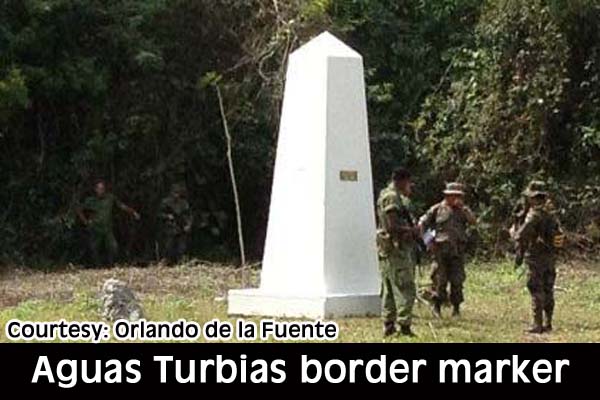
Orlando de la Fuente, a supporter and activist of Belize Territorial Volunteers, told Amandala that just a few weeks ago, he took a preliminary expedition to try to locate the marker at Aguas Turbias, which marks the tri-point where Belize shares borders with Guatemala and Mexico, at the very northwest corner of the country.
What de la Fuente found was a good example of how border markers are installed and maintained. A new Aguas Turbias border marker is situated 200 meters south of where the old marker was. Interestingly, he notes, on the new marker, there is a plaque for Guatemala facing its side of the border and a plaque for Mexico facing its side of the border, but no plaque for Belize. In fact, the name Belize, is simply penciled in.
De la Fuente said that he has ordered a plaque that looks just like the plaques that are there for Mexico and Guatemala, and he intends to have that plaque installed on Saturday, April 27, 2013, when he leads an expedition to the site, in commemoration of the 154th anniversary of the signing of the 1859 Boundary Treaty.
Mexico does recognize Belize’s border with that country. Our attempts to get information from the Mexican Embassy here on the new boundary marker proved futile. They told us they have no information.
De la Fuente notes that, “The boundary between Mexico and Belize is clearly demarcated with small white wooden posts every kilometer starting from the monument at Aguas Turbias.”
However, at Mexico’s border with Guatemala, heading west of Belize, the boundary clearing is even wider and there are permanent concrete white monuments about 200 meters apart, for as far as the eye can see, he added.
“For a few kilometers on the Belize boundary with Mexico, Mennonite farmers have built a road immediately within the boundary,” de la Fuente said. “There are fields of black beans planted right up to our boundary with Mexico.”
Of note is that de la Fuente and other Belizeans who took the trek to Aguas Turbias came upon a joint military patrol by Belize and Guatemala military. These are regularly scheduled “link-ups” along the border of Belize and Guatemala, in line with the Confidence Building Measures of 2005, concluded through the Organization of American States.
De la Fuente reported that, “Along the trail, we saw fresh vehicle tracks that we believed to be either drug traffickers or military. I was happy to see a BDF unit at the monument clearing. They had the area secured and were awaiting the arrival of a Guatemalan army unit.”
At the same time, a Guatemalan helicopter was landing at the clearing: “It delivered some troops that rendezvoused with elements of the Belize Defence Force at Aguas Turbias,” de la Fuente recounted.
The group plans to return to the site on April 27, 2013. De la Fuente told us that he intends to hoist a Belizean flag at the location. He had requested flags from both Mexico and Guatemala, because he also wanted to acknowledge those nations by raising their flags at the border marker.
De la Fuente told us of an interesting exchange he had with Guatemala’s Ambassador to Belize, Manuel Tellez, who declined to provide a Guatemala flag for the expedition on the claim that doing so would send the wrong message, that his office would be giving its endorsement.
According to de la Fuente, Tellez discouraged him from undertaking further activities at the site, and indicated to him that Belize signed an international document in 2005 saying that it accepts that what lies between the two countries out west is an adjacency line and not a border. De la Fuente said that the Ambassador would not call the marker a “border marker” but a “reference marker.”
Amandala contacted the Embassy of Guatemala in Belize City to speak with the Ambassador about his concerns over the expedition and its activities; however, we were advised that he was not available. We left our contact number but at the time of this report, we had not heard back from the Embassy.

