
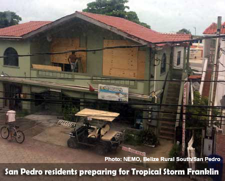
BELIZE CITY, Mon. Aug. 7, 2017–Tropical Storm Franklin—due to make landfall over the course of tonight on the Yucatan Peninsula, Mexico, with strong tropical storm force winds mostly impacting Corozal and the northern cayes in Belize—is expected to cause up to 12 inches of rainfall, triggering concerns about flashfloods over the course of the next few days.
At press time tonight, Franklin is a very strong tropical storm with maximum sustained winds of 60 miles per hour with gusts up to 70 miles per hour. If it strengthens, it will become the strongest cyclone of the season. If it becomes a hurricane, it would be the first for the 2017 season.
Feeder bands from Franklin began to spawn showers over Belize during last night and this morning, and as we go to press this evening, the storm is reportedly causing heavy rain and strong winds over Mexico’s Yucatan Peninsula.
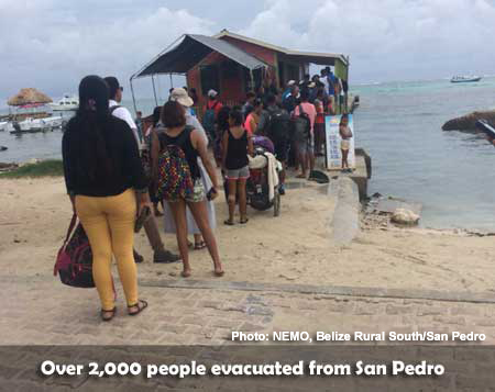
Vanessa Parham, the National Emergency Management Organization (NEMO) contact for Belize Rural South (San Pedro and Caye Caulker), told our newspaper this evening that since 6:00 a.m. today, 1,276 persons have been evacuated by boat and 781 by air (via Tropic Air and Maya Airlines).
There were many visitors on the island for the International Costa Maya Festival this past weekend, and the town council decided to also call for an evacuation of guests from the island.
The San Pedro High School and the Caye Caulker Village Council were opened earlier today to provide shelter services on the respective islands, and more shelters will be opened if necessary, Parham said.
According to the National Hurricane Center in Miami, “Rainfall amounts of 3 to 6 inches, with isolated amounts of around 12 inches, are possible across the Yucatan Peninsula of Mexico and Belize through Wednesday, with the highest amounts over the Mexican state of Quintana Roo. These rains could produce life-threatening flashfloods.”
Meteorologist Ronald Gordon, of the National Meteorological Service in Belize, told Amandala this evening that the cyclone, which may strengthen into a minimal hurricane before landfall, is expected to make landfall north of Belize, and possibly north of Chetumal, Quintana Roo, Mexico; however, tropical storm force winds of 40 miles per hour or stronger are expected to impact northern Belize. Belize City may experience tropical storm force winds in gusts during thunderstorms, he said.
Although southern Belize has not been included in the tropical storm warning in effect for Belize, when the system moves overland tonight and tomorrow, a southerly flow could push rains over southern Belize, Gordon explained. He told us that between tonight and Wednesday, the south and the coast could expect rainfall, especially at night. After mid-week, showers should become isolated, he said.
Cayo is also expected to experience impacts from Franklin – although more so from rainfall than from high winds.
Yesterday evening, NEMO issued its first advisory, warning that a tropical wave in the Caribbean could develop into a tropical storm. Around 10:00 last night, Franklin had progressed to tropical storm strength just northeast of Honduras, and around mid-morning, it had reached maximum sustained winds of 60 miles per hour.
Forecasters say that it could continue to strengthen before landfall, possibly reaching hurricane force, with maximum sustained winds of at least 74 miles per hour, and a hurricane watch is in effect for the coast of Mexico from Chetumal to Punta Allen.
If Franklin does become a hurricane, it would strike as a minimal category 1, which would mean that its impact on northern Belize could be greater than currently anticipated.
Gordon said, though, that the most intense winds are usually to the north of the storm, which would put Belize out of the storm’s most dangerous zone.
He said that the storm has intensified quite a bit since yesterday due to very warm sea surface temperatures, but upper level winds have been steering it north of Belize. Initially, Belize was included in the projected cone of uncertainty, which is now centered entirely over southern Mexico.
As a consequence of the approaching storm, the Philip S. W. Goldson International Airport closed operations at 5:00 p.m. today and operations will resume when the “all clear” is given. The second United Airlines and Southwest flights were cancelled for today.
Meanwhile, the Karl Heusner Memorial Hospital, the country’s only national referral hospital, announced that as of 12:00 p.m., it goes into emergency mode with the suspension of all non-essential services, including specialist clinics, administrative services, morgue services, high risk clinic, and medical imaging services. It will alert the public when regular services resume.
In its mid-afternoon advisory, NEMO said that bus runs continue from Belize City to northern, central and southern Belize, but they would be suspended at 5:00 p.m. for northern Belize and 6:00 p.m. for elsewhere in the country. Water taxis provided services until 4:30 p.m.
According to NEMO, 6 shelters were opened in the Corozal District at 4:00 p.m.: Sarteneja R.C. School, Chunox Community Center, Copper Bank Inn, Progresso R.C., Church of Christ and Guadalupe R.C.
“Fuel stations in Belize City, Orange Walk, will remain open to the public during normal hours of operations and in Corozal, Sol [service station] in Ranchito [village] will be open throughout the night. Fuel stations will close as follows: 6:00 p.m. – One Stop Orange Walk; 7:00 p.m. – One Stop Belize Shell Ladyville Shell Xabel; 9:00 p.m. – Shell San Ignacio, Shell Belmopan, Buca Belize,” NEMO said, adding that all will reopen on the “all clear.”
NEMO advised the public to remain vigilant, listen carefully to their radios and take actions based on the advice given by NEMO and the National Meteorological Service.
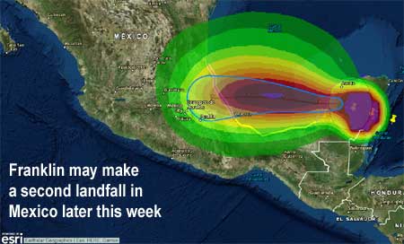
Franklin is the sixth named storm for the 2017 Atlantic Hurricane Season, and the first major system to threaten Belize so far this year. Notably, it could make a second landfall in Mexico later this week after moving across the Bay of Campeche.
The Atlantic Hurricane Season runs from June to November, and it peaks around September 10.
Forecasters at NOAA’s Climate Prediction Center predict an above-normal hurricane season for the Atlantic this year. They predict a 70% likelihood of 11-17 named storms (winds of 39 mph or higher), of which 5-9 could become hurricanes (winds of 74 mph or higher), including 2-4 major hurricanes (Category 3, 4 or 5; winds of 111 mph or higher). An average season produces 12 named storms, of which six become hurricanes, including three major hurricanes.