
by Charles Gladden
BELIZE CITY, Mon. Oct. 21, 2024
At 3:00 p.m. on Friday, October 18, the National Emergency Management Organization (NEMO) declared that the Corozal, Orange Walk, and Belize Districts would be placed under a Tropical Storm watch in preparation for the potential landfall of Tropical Storm Nadine.
At that time the system was located about 210 miles east of Belize City, moving to the west-northwest at 7 mph with maximum sustained winds of 35 mph with the possibility of strengthening to 50 mph, and predicted to arrive around midday on Saturday, October 19.
“The main threat from this system for the country of Belize is going to be heavy rainfall and that activity has already started. We are seeing outer bands of showers and thunderstorms moving across the country from this system and those are expected to continue throughout the evening and tonight and intensify into tomorrow morning. Rainfall estimates are about 4 – 8 inches at the higher end and based on the current trajectory, the highest amount of rainfall will be in the extreme north of the country,” said Ronald Gordon, Chief Meteorologist for the National Meteorology Service.
“Indications are that the center of the system will move somewhere north of Belize City and possibly make landfall over northern Belize or even across the border in Mexico… This system is within 24 hours of a potential landfall, so residents should be paying attention and monitoring the system’s impacts over the country. South of Belize City will be relatively minimal in terms of winds, but the rainfall potential is for the entire country, so we need to be on alert for possible flooding,” he added.
“The flash flood risk in the first 12 hours is not positive. However, within the 24 under 36-hour window, that risk increases to a medium-high potential for flash flooding… the Rio Hondo, the New River, portions of the Belize River are forecasted to have flood levels,” said Tennielle Hendy, Chief Hydrologist at the National Hydrologist Service.
Thankfully, Nadine did not strengthen beyond predictions and Belize only sustained some gusty winds; however, the storm did bring the forecast significant rainfall which caused flooding in some areas.
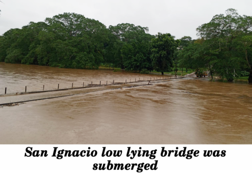
As predicted by Chief Hydrologist at the National Hydrologist Service, Tennielle Hendy, neighborhoods in Corozal Town and its rural communities, as well as some villages in the Orange Walk District experienced severe flooding. The Cayo District also received significant rainfall, which resulted in the low-lying bridge that connects the twin towns of Santa Elena and San Ignacio going underwater.
“We’re seeing approximately 25 to 30 feet of water in some areas. So, it’s far exceeding, you know, just the normal little flood we normally get with excessive rainfall. We’re seeing it approach those historical levels,” Hendy said.
Notably, there was excess water at the Vaca Dam which is located at the Mopan River on the outskirts of the Mountain Pine Ridge Forest Reserve in the Cayo District.
Hendy advised persons living near the Mopan River to monitor the river as the overflowing dam may cause flooding.
“You know the dams act as flood control. So, they’re holding back a lot of the floodwaters that we’re not seeing because of that function that they have. [However] our analysis has shown that when we have the Vaca spillways active, there is an influence on flooding to downstream users. Specifically, for the Mopan-Macal Belize River system, we recommend that residents continue to monitor the river levels. These river levels tend to come up very quickly…and we don’t want anyone to be caught off guard,” she said.
Hendy said that the Macal River reached 15 feet above its normal level. While a full analysis is yet to be done of the Rio Hondo, the National Hydrologist Service said water levels are still rising and have the potential to runoff into rural communities of the Belize District but not with the same effect as other areas.