
Photo: Corozal Bay the morning after Hurricane Beryl made landfall near Tulum
Authorities deem it a learning experience
BELIZE CITY, Mon. July 8, 2024
The scare of historic Hurricane Beryl is behind us, and everyone in Belize is breathing a sigh of relief. Residents in the Corozal District – most expected to be impacted by rains and winds from Beryl feeder bands impacting the Yucatan – experienced practically no effects (save for drizzling and brief periods of rain) as the system made landfall near Tulum as a category 2 hurricane around 4:00 a.m. on Friday. The highest wind gusts were recorded in Ranchito Village at 34 miles per hour. Belize’s National Emergency Management Organization (NEMO) announced the All-Clear at its daily briefing at 7:30 on Friday morning, and business – which had been interrupted in areas where a Tropical Storm Watch had been in place — started returning to normal immediately.
Ronnie Hernandez, the District Emergency Coordinator for Corozal, on Friday remarked, “We are safe.” He commended the Corozal Emergency Operation Committees that worked through the night on 6-hour shifts. They had bunkered down at the Command Operation Center at the Town Council, where they were tracking the storm live. According to Hernandez, though some residents made the request, they did not see the need to open any shelters. He did note that there were some constraints with a few of their committees, and Beryl served as a teaching moment.
Speaking on Beryl tracking further north and skipping Belize altogether, Corozal Mayor, Rigo Vellos, commented, “It shows that God has His blessings on us still as a country, and of course as a district. And we need to be thankful …” Vellos committed to keep on working with NEMO and to continue to prepare. He further stated, “We might have been lucky for this one, but we don’t know if that will continue for us for the rest of the hurricane season … Don’t believe that because this one missed us, we’ll always be lucky. We need to continue preparing.” The next process for the Council, according to Vellos, is to ensure that all drains are properly maintained, and he admitted that they still need to do some more work in that regard. Vellos believes that the emergency response apparatus would work well, but they can enhance it.
Asked if he was satisfied with the performance of the Corozal District Emergency Management apparatus, Daniel Mendez, NEMO’s National Emergency Coordinator, said they were clearly prepared, since they had been on the ground for days in advance. Mendez also highlighted that everyone should be asking themselves: “If this system had come our way, were you ready for it?” He advised that for those who don’t respond in the affirmative, they have a chance to improve. In the case of NEMO, Mendez says they are always improving. He affirmed, “We are taking these lessons. We are internalizing them, and we will be taking actions on those areas that we see were weaker, and we will be strengthening those areas that we have seen to be much stronger.”
NEMO needs to optimize communication
One area that needs to be tightened at NEMO is communication with the public. For a second time, a post made on the Facebook page for NEMO caused confusion this season. Less than an hour after the NEMO 7:30 a.m. press conference on Thursday, when Chief Meteorologist Ronald Gordon said they saw no need to upgrade the Tropical Storm Watch to a Warning for Belize City up to the northern border, a post went up on NEMO’s Facebook page stating there was a Tropical Storm Warning in effect. It was promptly taken down after people started asking questions. We also sought clarification from Mendez as to whether NEMO itself was following the recommendations and analysis provided by the National Meteorological Service, given that Gordon said they had resisted pressure to increase the alert to a Warning. Mendez replied that they are exploring new ways of reaching the public, and one of those is social media use. He explained that Thursday’s post was not intentional, and they are still learning the power of social media and the reach that NEMO has across the country. He stated, “We are now more careful with these, because we understand that anything that we post is immediately listened to by the public …” He then added that, in regard to the collaboration with the Met Service, there is no doubt of that, as they constantly touch base with them and the Hydrological Service throughout the day.
Another aspect that Mendez says they need to streamline is the announcement of the All-Clear, given that in their 9:00 p.m. advisory, they had already indicated that if all conditions remained the same, businesses in the Watch area could reopen on Friday. However, the All-Clear came on Friday morning at the press conference. He said they will revisit their messaging to be clearer.
Difference between a “Watch” and a “Warning”
For his part, Gordon found it necessary to explain the difference between a Watch and a Warning. After taking note of the public’s confusion, Gordon shared, “A Watch means that you get ready; you do not need to take drastic actions — it means you prepare. It’s to raise your level of preparedness and your alertness to be watching and monitoring carefully. And Warning would have been different. If we had issued a Warning, it means that it’s time to take action; it’s time to evacuate if you’re in a vulnerable area. So, certainly, those are things that we will move forward along with NEMO to ensure that we coordinate more properly …” Gordon said that they intend to give greater consideration to extending the period of the alerts to give people more time to mobilize beyond 24 hours.
When will ocean temperatures cool? Chief Met emphasizes state of readiness
Weather modelling systems have difficulty predicting level of intensity, therefore, our Met Service could not indicate with precision the extent to which warm ocean temperatures would impact Hurricane Beryl’s intensity. At the outset, it was predicted it would be a Category 1 hurricane by the time it reached our area; however, as the system was nearing landfall in the Yucatan Peninsula, it was a Category 2 hurricane. We asked Chief Meteorologist Ronald Gordon if sea temperatures are expected to decrease anytime soon, keeping in mind that the hotter temperatures are seen later in the year around September. Gordon said it is difficult to say, but after any major hurricane, there is a “cool wake,” given that the hurricane would have stirred up the ocean waters, “allowing mixing, so the cool waters from below will mix with the warmer water from above.” “So, it cools down a bit. So, typically, you don’t see one major hurricane right behind the other. And that’s not to say it cannot occur,” he further explained. However, the Chief Met cautioned that the Atlantic Ocean and the Caribbean Sea are anomalously warm, “so certainly, we do know that there is a potential for more systems to come our way and we need to be on the alert.”
Thanks to Met Service and NEMO personnel
Both the Chief Met and Mendez expressed gratitude to their staff who were in overdrive, ensuring that things functioned as they should, and that the public was kept informed. Gordon commended his technical and administrative staff saying, “We have a very dedicated team from our administrative support staff. Certainly, we can’t do without them or without our weather observers or weather forecasters or data analysts; our technicians who ensure that our instruments are working properly, people who are very dedicated and committed to duty; our web designer who came back from vacation to ensure that everything was up in our website and that [the] message was going out to the public. I am very grateful to these persons, their dedication to duty. Without them, we are not able to do this work. And by extension, I would like to also thank our partners in emergency management, including the National Emergency Management Organization, NEMO, for their collaboration and their work with us. I don’t want to forget the National Hydrological Service who was there supporting us in terms of giving us the flood forecasts and alerts. We are certainly thankful for that.”

Cabinet held emergency meeting on Beryl
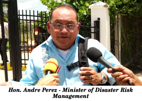
On Thursday morning, Cabinet held an emergency meeting to discuss the threat of Beryl, but by then it was clear that there would be no direct hit on Belize. Minister of Disaster Risk Management, Hon. Andre Perez described it as a learning opportunity. He detailed that over 4,328 people had voluntarily evacuated from Ambergris Caye and Caye Caulker via water taxi (at a price of $88 for a round trip, that’s over $380,000) and another 1,500 via flights.
Deputy Prime Minister Cordel Hyde remarked, “I know it’s been scary times, but thankfully we’ve been spared …” He cautioned, though, about being prepared for the remainder of the season. He noted, “It would seem to us that we are at more risk than we’ve ever been – that this season may be one for the ages, and so we have to do everything that is possible within our financial means, within our resources to be prepared. There’s a lot more things we have to do. I think the last week has really shown us where we are, where we have shortcomings, where we need to do better.” He stated, though, that “only God can help us” if we get a really, really big hurricane.
We asked Hyde about having eliminated, in his division, almost all “London bridges,” a reference to the makeshift bridges of wooden pallets and boards used as walkways in swampy areas within Belize City. Hyde highlighted that the problem is, “when you abolish London bridges, more come up … But I think the City Council has to take on some of that heavy lifting in conjunction with the area representatives to really tackle those, because when there’s a hurricane, when there is a weather, it is very, very hard to navigate, very, very hard for those folks who are practically in the water.” In his case, Hyde says he will try to rid his division of the remaining London bridges “before the season passes.”
Talk show host points to unpleasant realities after Beryl
WUB Morning Vibes talk show host, Evan “Mose” Hyde has pointed to the urgent need for Belize to heighten its disaster risk management plan based on the “unpleasant realities that Beryl screams at us.” He pointed to two alterations we are now facing, with one being less time to prepare due to the rapid intensification of weather systems. The other is that, “The probability has just increased of being hit by a Category 5 storm. It was already increasing; this now means, because there is less time required to become Category 5 based on all the favourable conditions that exist, now, you are looking at, if a Category 5 hits you once every 100 years, there is a [period of] probability that is now reduced.” Speaking specifically of what Carriacou experienced, Hyde detailed, “It was at 35 mph and in 24 hours, went to a Category 1. In a next 24 hours it went to a Category 4. And then within a next 24 hours, they were struck. It means, all told, they had 72 hours between a storm going from 35 mph to being a strong Category 4 storm making landfall. That is an incredibly short period of time for you to prepare for something that has never happened to you before.”
Hyde emphasized the need for disaster risk management authorities to “redesign their outreach into communities where, because of their financial realities, because of the things they have to consider, they generally, in our experiences we’ve had, will be the last to make a decision to move because it’s too costly, and because generally they have to go to unsafe spaces … they have to go into some room maybe in Belmopan. They are reluctant and hesitant, naturally. And you are now working with less time …” With many exposed, vulnerable communities along our coast, Hyde says authorities need to start going into those communities now, and begin proper planning for those communities.
CARICOM sister nations to help Beryl-impacted states
On Friday, CARICOM held a virtual 20th Special Emergency Meeting of Heads of Government to discuss relief for countries heavily impacted by Beryl. Prime Minister John Briceño pledged a financial contribution toward the recovery efforts in St. Vincent and the Grenadines as well as Grenada, and offered to send linesmen to assist with the restoration of electricity.
For its part, the United Nations has provided US$4 million to kick-start relief efforts in the islands of Grenada, St. Vincent and the Grenadines and Jamaica.
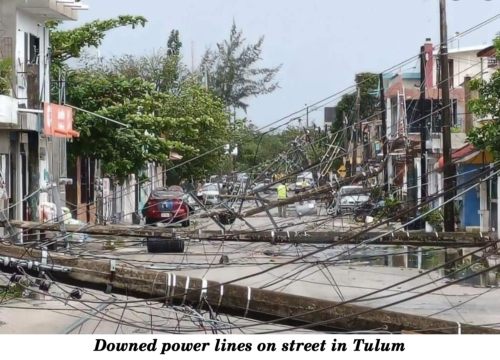
Beryl battered Tulum as Cat 2 system and claimed two lives in Texas
Beryl touched down near Tulum in Mexico’s Yucatan Peninsula as a strong Category Two hurricane on Friday, June 5. It packed winds of 108 mph and gusts reaching 136 mph. Mexican authorities instituted a curfew ahead of the intense rains that battered the area, triggering warnings of potential rainfall accumulation of up to 10 inches. Fortunately, though, Beryl did not cause major damages in Tulum, though there were many downed trees and power lines and minimal impacts to housing stock and infrastructure. Both tourists and residents were evacuated to shelters, though a majority chose to battle out the storm at home.
After exiting Mexico’s Yucatan Peninsula as a tropical storm, Beryl made its way to the Gulf Coast of Texas, where it made landfall near the coastal town of Matagorda as a Category 1 hurricane around 4:00 a.m. Central Time today, Monday, with winds of 80 mph. Over 2 million electricity users were left without power in the Houston area this morning, and at least two people died in Harris County as a result of trees that fell on homes. Hundreds of flights were cancelled, including over 500 flights out of Houston’s George Bush International Airport.
The system strengthened into a hurricane just hours before landfall in Texas. Beryl is the first July hurricane to make landfall in Texas since Hannah in 2020, and the earliest landfalling hurricane in Texas since Bonnie, which made landfall on June 26, 1986. Beryl became a named storm on June 29, 2024, and a hurricane on June 30.
Beryl, which made landfall three times, is expected to weaken to a tropical storm today and then to a tropical depression on Tuesday.