BELIZE CITY, Thurs. Sept. 2, 2021– This week, the Government of Belize, by way of the Ministry of Sustainable Development, Climate Change, and Disaster Risk Management, released its updated National Climate Change Master Plan 2021-2025.
The five-year plan is geared toward building the country’s capacity to reduce greenhouse gas emissions and adapt to the challenges of Climate Change, as agreed upon in the 2015 Paris Agreement.
Countries globally agreed in 2015 to work toward keeping the increase in global temperatures below 1.5% and were charged with releasing their National Determined Contributions (NDC) toward the achievement of that goal.
Belize released its first NDCs in 2016 and has now updated those goals — with the objectives it plans to reach being augmented by 5%.
This National Climate Change Master Plan builds on the Climate Action Plan of 2015-2020.
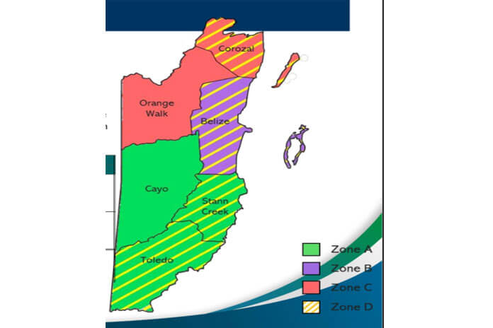
According to the climate models in the updated master plan, Belize’s geography is separated into regions. Zone A is situated on the slopes of the Maya Mountains and is crossed by the Macal River and the Rio Grande.
Zone B is crossed by rivers whose tributaries originated in Zone A primarily This is the most densely populated zone.
Zone C is the flat zone, with few rivers, including the Rio Grande.
Finally, there is Zone D, the areas with direct access to the sea and the hub of the majority of economic activity in Belize.
This zone will be the first to feel the impact of sea-level rise brought on by Climate Change. The climate projections of sea level rise in Belize show an increase of sea level of approximately 9 cm in the next 25 years, an estimated average of 19.3 cm in 50 years, an average of 41.6 cm in 75 years and a 76 cm increase in the next 100 years.
The projections are based on three Representative Concentration Path (RCP) models.
The plans also anticipate an increase in sea surface temperature, with the areas between Ambergris Caye and the mainland being the hottest sections of our sea.
The data in the master plan show Zone C being prone to droughts and being the hottest, driest portion of the country’s territory. The report states that annual rainfall is expected to decrease, with seasonal anomalies increasing in the wet season and remaining constant in the dry season.
“Summing these two results, it can be deduced that rainfall will fall in extreme events rather than spread along all the season,” the report says.
And with warmer sea surface temperatures will come an increased probability of the development of hurricanes that can rapidly intensify, as has been seen recently in the formation of Hurricane Ida and last season in both hurricanes Eta and Iota.
Also, an increase of air surface temperatures inland means that storms will lose less energy when they make landfall. Data shows that in the last 25 years, hurricanes making landfall increased by 1.5%. Zone C, which includes the Orange Walk, and Corozal Districts, is the hottest and driest zone, making the potential energy transfer to storms a huge risk factor for that area.
Zone A, inclusive of Cayo, Stann Creek and Toledo, is the rainiest area and is at a high risk of river overflow and flash flooding.
Zone B is also susceptible to flooding from overflowing tributaries coming from Zone A. The Belize District is located in this zone, which is also at high risk for river overflow and hurricanes, as well as high risk of heavy rainfall.
Also as the most populated zone and a coastal area, the risks posed to Zone B by sea-level rise are considerable.

