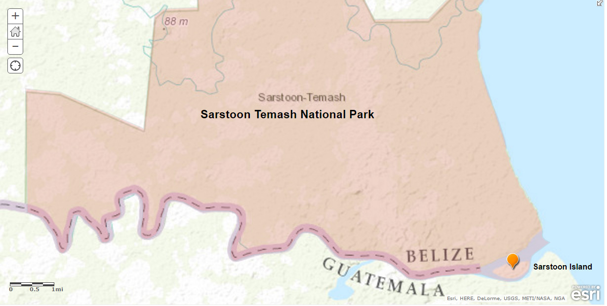
BELIZE CITY, Mon. May 16, 2016–Spanning 41,000 acres in the south-eastern tip of Belize, the Sarstoon-Temash National Park was established in March 1994 under the hand of then Natural Resources Minister Eduardo “Dito” Juan, with the southern edge of the park running right along Belize’s international border with Guatemala. Amandala has been able to confirm from official sources, as well as the legislation itself, that the national park actually includes Sarstoon Island.
There was one amendment to the law in 2000, when then Natural Resources Minister John Briceño, who is now the Opposition Leader, de-reserved about 40 acres between Boom Creek and Barranco, near the mouth of the Temash River. Briceño told us today that there was never any intention to exclude Sarstoon Island from the national park.
The revelation is noteworthy in the face of Guatemala’s assertion that it would exercise sovereignty over the entire Sarstoon. In fact, we have recently reported that Belizean military, as well as conservationists working with the Sarstoon-Temash Institute for Indigenous Management, (SATIIM) have recently been blocked from entering the park. The Belize military was impeded by the Guatemalan military, but it was the BDF which reportedly stopped SATIIM.
Recently, SATIIM posted videos and photos on its website documenting the incursions by Guatemala’s military into the park.
According to SATIIM, on May 5, 2016, the same day the BDF stopped SATIIM from accessing the river, about 5 minutes after SATIIM’s patrol arrived at the forward operating base manned by Belizean military 2 Guatemalan military boats started moving slowly from their base, on the Guatemalan side of the border, towards the Sarstoon River.
SATIIM reported that one of the boats entered the northern channel of the river, whilst the other moved slowly in the southern channel, apparently prepared to intercept any vessel from entering the Sarstoon River.
In effect, the Guatemalans have been blocking Belizean conservationists and military from entering an internationally recognized national park under Belize’s jurisdiction. We note that the national park’s habitat is listed as wetlands with prestigious international status under the RAMSAR convention, due to its rare Sphagnum moss, which supports great biodiversity.
The legislation passed in 1994 and 2000 explicitly details the southern border of the park as Belize’s southern border with Guatemala from “the mouth of the said [Sarstoon] river to a point located in the Deepest Channel on the Sarstoon River, on the Belize/Guatemala border… thence West following the Belize/Guatemala border” to where the park boundaries begin at UTM coordinates 276,000 East and 1,760,000 North, well beyond the midway point of the riverine boundary.
Froyla Tzalam, SATIIM’s executive director and the recently installed chair of the Association of Protected Areas Management Organizations (APAMO), confirmed to Amandala that the park includes that territory encompassing the Sarstoon Island.
Greg Ch’oc, who previously served as SATIIM’s executive director, concurred that Sarstoon Island is a part of the national park, and that SATIIM has for 15 years monitored the island. He added that US Capital, the oil company which did exploration inside the national park, had their camp there as well.
The co-management agreement between SATIIM and the Government of Belize fell apart while SATIIM and the Government sparred over oil exploration in the national park, which has been subject to illegal fishing, illegal logging, illegal hunting and other such activities.
“SATIIM realizes that just the mere presence of Belizean law enforcement in hot spots can do much to deter illegal activities. The patrol team observed many gill net sites on the Temash River, an area that does not have much traffic,” the NGO said, citing increased security presence in some parts of southern Belize, including near Barranco, one of the villages adjacent to the park.
In its description of the park, APAMO noted that activities within the protected area include those of a non-extractive nature – tourism, education and research; as well as sustainable extraction of non-timber forest products.
Recently, the Barrow administration passed legislation to stop civilians from visiting the Sarstoon area, but later made amendments to allow only limited access authorized by the Government.
SATIIM said that it is committed to its regular patrols to the neglected Sarstoon Temash National Park and is hopeful that talks between Guatemala and Belize provide a framework for travelling in the Sarstoon River in the very near future.
In a statement released today, the Government of Belize said that Foreign Ministers from Belize and Guatemala are scheduled to discuss a “cooperation mechanism” for the Sarstoon in Istanbul, Turkey on Saturday, May 21, 2016.
“It is therefore expected that if the Istanbul talks do not produce any immediate final agreement, the OAS will host follow up meetings in Washington D.C.,” the official release said.

